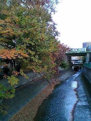
Kanda River revisited


My river quiz a few weeks ago was a more difficult than I had imagined, with the two winners getting two of the five photos right. The Kamo River in Kyoto was easy, and the Arakawa Dam up in the Chichibu region of Saitama could be found in a previous post about Arakawa River (should that be called the Ara River, by the way?).
The others are: Kanda River, Koma River and Sagawa River (that one is near Tama river between Tokyo and Kanagawa prefecture, and was in the news this year as typhoon Fitow wrecked an old bridge).
Kanda River is a man-made canal that runs through Tokyo, and is connected to the Imperial Moat and the Sumida River. It played an important role for the economy before the age of cars and express highways, but Kanda river was actually created to avoid floods in the Edo era. Hiroshige included it in several of his famous views from the capital. My photo is from a bridge just north of Takadanobaba station, and if you look really hard, you can see the green Yamanote line train going north to Ikebukuro.

I used to live near Tokyo Dome in Suidobashi, where Kanda passes, and there is a train station called Kanda with many bookshops. This is not a picturesque canal by any means, but when the Sobu line passes it, I always feel reminded of Tokyo's past, as a city of water. Thanks for participating in the quiz!
(Hiroshige: Kanda River, Shohei Bridge and Seido Hall, 1857)


Comments
Sustainable living, one of my pet topics here, has gotten me wondering about the sustainability of Edo era Japan in the 1600-1850s. I might get back to that topic, although I'm sure others have covered it much better than I can.
Cheers and a happy new 2008.